

Combining cellular and ADS-B data, NAVSentry and GPSwise set a new standard in digital airspace security and situational awareness.
[Vienna, Austria / Zurich, Switzerland] – Dimetor, a global leader in connectivity and data analytics for the comms, defense, and aerospace industry, and SkAI Data Services, the developers of the world’s first real-time ADS-B GPS spoofing and jamming tracker (GPSwise), are announcing a strategic partnership that marks a groundbreaking leap in global airspace security. By joining forces, the two companies will deliver a comprehensive, holistic solution for monitoring GNSS disruptions, covering both lower and upper airspace, for crewed and uncrewed flight operations and other users worldwide.
Rising threats, rising need for real-time awareness
In today’s hyperconnected world, GNSS signals (like GPS) are the backbone of aviation, drone operations, critical infrastructure, and the global supply chain, amongst others. Yet, they remain vulnerable to ever-increasing risks: spoofing, jamming, and unintentional interference; disruptions that have real-world consequences, from delayed flights and lost cargo to compromised navigation safety and security.
As incidents of GPS jamming and spoofing surge globally, the need for reliable, real-time situational awareness has never been more urgent.
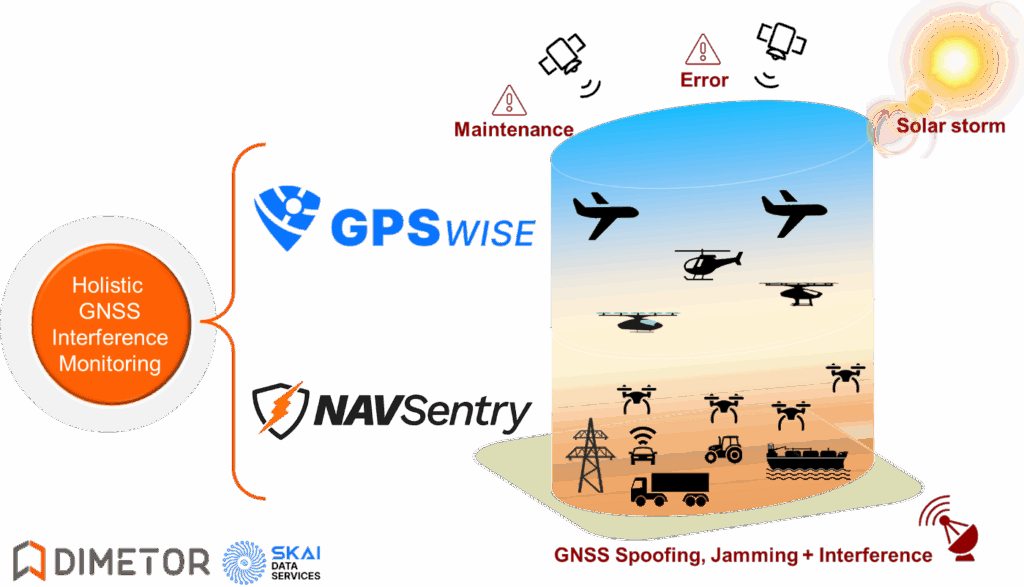
A partnership built on complementary strengths
SkAI Data Services created GPSwise in partnership with the Zurich University of Applied Sciences – Centre for Aviation. The platform is already trusted by airlines, airports, air navigation service providers, and authorities worldwide to provide ADS-B-based awareness of GPS threats.
Dimetor’s NAVSentry platform is an AI-powered solution for detecting GNSS disruptions in real time, combining different technology layers, and securing Position, Navigation, and Timing (PNT) data across autonomous and crewed systems, from multiple data sources:
- Cellular network data
- Satcom based detection mechanisms
- Other network-based sensors
- Dedicated ground-based receivers
This multi-layered approach delivers actionable, real-time intelligence to aerospace, critical comms, UTM/ATM, UAV operators, logistics, critical infrastructure sectors, law enforcement, spectrum authorities, defense and intelligence, amongst others.
What makes this partnership unique?
Dimetor and SkAI Data Services have signed a Memorandum of Understanding (MoU) to combine two fundamentally different, yet highly complementary data streams, ADS-B-based information and data from terrestrial sensor networks, such as 5G.
This integration creates, for the first time, a unified view of GNSS health across the full airspace, both crewed and uncrewed, at all altitudes, in real-time.
Key benefits of the integrated solution
- Full-airspace coverage: Simultaneous monitoring of upper and lower airspace, from airports and airliners to drones, ground vehicles, and critical infrastructure.
- Real-time alerts and visualization: Instant awareness and actionable intelligence for service operators, governmental and civil authorities, and security teams.
- Event-based and continuous monitoring: Catching both sudden, event-driven attacks (like spoofing/jamming) and persistent low-level interference.
- Data-driven decision making: Empowering professionals in aerospace, logistics, maritime, cybersecurity, and multiple other domains to respond rapidly and effectively.
- Global reach: Both platforms together leverage a global sensor network, from dedicated devices and telecom infrastructure to ADS-B aircraft data worldwide.
A milestone for GNSS Monitoring
“This partnership with SkAI Data Services and GPSwise allows us to close the gap between lower and upper airspace monitoring,” said Thomas Neubauer, CEO and co-founder of Dimetor. “For the first time, we can offer our NAVSentry customers a truly holistic, real-time picture of GNSS integrity, giving aviation, UTM, and critical infrastructure operators the tools they need to stay ahead of threats.”
“GNSS interference doesn’t stop at the airport fence or at 400 feet,” added Raphael Monstein, Co-Founder of SkAI Data Services. “By joining forces with Dimetor, we are connecting the dots from lower digital airspace to higher altitudes, making airspace safer and more resilient for everyone.”
Who stands to benefit?
- Aviation authorities and air navigation service providers (ANSPs)
- Airlines, airports, and drone operators
- Critical infrastructure providers (energy, logistics, transport)
- Maritime and ground transportation sectors
- Cybersecurity professionals and emergency response teams
- Law enforcement
- Spectrum management agencies
- Defense contractors and authorities
About Dimetor
Dimetor is a Vienna-based technology company specializing in telecom-driven, AI-powered data solutions for aviation and autonomous systems. Dimetor’s platforms, including AirborneRF and NAVSentry, bridge the gap between mobile networks and airspace users to ensure safety, compliance, and operational efficiency. For more information, visit dimetor.com.
About SkAI Data Services / GPSwise
SkAI Data Services, a spin-off of the Zurich University of Applied Sciences, is the developer of GPSwise, the world’s first live GPS spoofing and jamming tracker. GPSwise provides real-time global monitoring of GNSS interference incidents, trusted by stakeholders across aviation, maritime, logistics, and cybersecurity. For more information, visit gpswise.aero.